File:China administrative zh-hans.svg

Size of this PNG preview of this SVG file: 735 × 599 pixels. Other resolutions: 294 × 240 pixels | 589 × 480 pixels | 942 × 768 pixels | 1,256 × 1,024 pixels | 2,511 × 2,048 pixels | 857 × 699 pixels.
Original file (SVG file, nominally 857 × 699 pixels, file size: 888 KB)
| Description |
中文(简体):中华人民共和国行政区划地图(简体中文版)
中文(繁體):中華人民共和國行政區劃地圖(簡體中文版)
English: Administrative Divisions of the People's Republic of China (Simplified Chinese Version) |
| Source |
中文(简体):行政区划论坛的woodhome及hunry所作的全国分县图。
English: Base map made by woodhome and hunry of the XZQH forums. |
| Author | User:Ran, Convert to SVG by User:PhiLiP |
| Other versions |
[]
PNG:
GIF:
|
| SVG development |


.png)


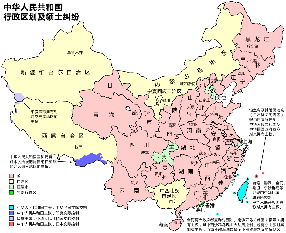
中华人民共和国行政区划。上传者所作。底图为行政区划论坛的woodhome及hunry所作的全国分县图。
图上显示的为新省界,同时也将所有争议地区标出。(南海诸岛由于覆盖面积大,情况复杂,故未上图)由于中俄已就边界问题达成协议,两国争议区域没有标出,其中黑瞎子岛为一边一半。

|
Permission is granted to copy, distribute and/or modify this document under the terms of the GNU Free Documentation License, Version 1.2 or any later version published by the Free Software Foundation; with no Invariant Sections, no Front-Cover Texts, and no Back-Cover Texts. A copy of the license is included in the section entitled GNU Free Documentation License. |
| This file is licensed under the Creative Commons Attribution-Share Alike 3.0 Unported license. | ||
| ||
| This licensing tag was added to this file as part of the GFDL licensing update. |
File history
Click on a date/time to view the file as it appeared at that time.
| Date/Time | Thumbnail | Dimensions | User | Comment | |
|---|---|---|---|---|---|
| current | 14:40, 3 February 2008 | | 857 × 699 (888 KB) | PhiLiP | fix 有 to 由. |
| 13:30, 3 February 2008 |  | 857 × 699 (889 KB) | PhiLiP | {{Information |Description=Administrative divisions of the People's Republic of China - Simplified Chinese version. 中华人民共和国行政区划地图-简体版。 |Source=行政区划论坛的woodhome及hunry所作的全国分县图 |
File usage
The following page uses this file:
Global file usage
The following other wikis use this file:
- Usage on wuu.wikipedia.org
- Usage on zh.wikipedia.org