File:Bundesarchiv Bild 183-L09218, Berlin, Japanische Botschaft.jpg
Size of this preview: 448 × 600 pixels. Other resolutions: 179 × 240 pixels | 567 × 759 pixels.
Original file (567 × 759 pixels, file size: 97 KB, MIME type: image/jpeg)
Summary
| Photographer |
Unknown |
||||||||||||||||||||||||||
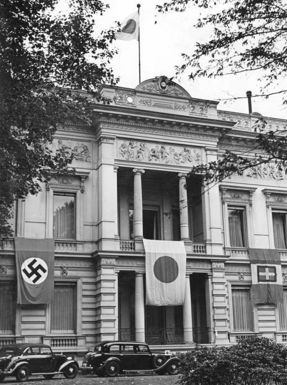
| Original caption |
For documentary purposes the German Federal Archive often retained the original image captions, which may be erroneous, biased, obsolete or politically extreme. Berlin, Japanische Botschaft
ADN-ZB Berlin 1940: Im faschistischen Deutschland. Die japanische Botschaft in der Tiergartenstraße. 8309-40 [Berlin.- Japanische Botschaft in der Tiergartenstraße mit Hakenkreuzflagge, Flagge des Kaiserreichs Japan und Italien] |
||||||||||||||||||||||||||
| Depicted place | Berlin | ||||||||||||||||||||||||||
| Date | September 1940 | ||||||||||||||||||||||||||
| Collection |
|
||||||||||||||||||||||||||
| Current location |
Allgemeiner Deutscher Nachrichtendienst - Zentralbild (Bild 183) |
||||||||||||||||||||||||||
| Accession number | |||||||||||||||||||||||||||
| Source |
|
||||||||||||||||||||||||||

English: In fascist Germany, the Japanese Embassy on Tiergartenstraße with the Nazi Flag, the Japanese Imperial Flag, and the Italian Flag
Licensing
This file is licensed under the Creative Commons Attribution-Share Alike 3.0 Germany license.
Attribution: Bundesarchiv, Bild 183-L09218 / CC-BY-SA 3.0
- You are free:
- to share – to copy, distribute and transmit the work
- to remix – to adapt the work
- Under the following conditions:
- attribution – You must give appropriate credit, provide a link to the license, and indicate if changes were made. You may do so in any reasonable manner, but not in any way that suggests the licensor endorses you or your use.
- share alike – If you remix, transform, or build upon the material, you must distribute your contributions under the same or compatible license as the original.

| Object location | | View this and other nearby images on: OpenStreetMap |
|---|
| Camera location | | View this and other nearby images on: OpenStreetMap |
|---|
File history
Click on a date/time to view the file as it appeared at that time.
| Date/Time | Thumbnail | Dimensions | User | Comment | |
|---|---|---|---|---|---|
| current | 03:47, 24 October 2012 | | 567 × 759 (97 KB) | Cropbot | upload cropped version, operated by User:jay8g. Summary: cropped |
| 17:33, 4 December 2008 |  | 592 × 800 (106 KB) | BArchBot | == Summary == {{Information |Description={{de|1='''Berlin, Japanische Botschaft''' ADN-ZB Berlin 1940: Im faschistischen Deutschland. Die japanische Botschaft in der Tiergartenstraße. 8309-40 [Berlin.- Japanische Botschaft in der Tiergartenstraße mit |
File usage
The following 2 pages use this file:
Global file usage
The following other wikis use this file:
- Usage on ar.wikipedia.org
- Usage on ast.wikipedia.org
- Usage on azb.wikipedia.org
- Usage on az.wikipedia.org
- Usage on bg.wikipedia.org
- Usage on ca.wikipedia.org
- Usage on cs.wikipedia.org
- Usage on da.wikipedia.org
- Usage on de.wikipedia.org
- Usage on el.wikipedia.org
- Usage on en.wikipedia.org
- Usage on eo.wikipedia.org
- Usage on es.wikipedia.org
- Usage on fa.wikipedia.org
- Usage on fr.wikipedia.org
- Usage on gv.wikipedia.org
- Usage on he.wikipedia.org
- Usage on hi.wikipedia.org
- Usage on hy.wikipedia.org
- Usage on id.wikipedia.org
- Usage on it.wikipedia.org
- Usage on ja.wikipedia.org
- Usage on ko.wikipedia.org
- Usage on la.wikipedia.org
View more global usage of this file.