File:2006megacities.svg

Size of this PNG preview of this SVG file: 800 × 351 pixels. Other resolutions: 320 × 140 pixels | 640 × 281 pixels | 1,024 × 449 pixels | 1,280 × 561 pixels | 2,560 × 1,123 pixels | 1,425 × 625 pixels.
Original file (SVG file, nominally 1,425 × 625 pixels, file size: 1.42 MB)
Summary
| Description |
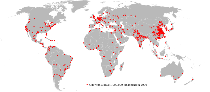
English: This map shows the global distribution of top 400 "urban areas" with at least 1,000,000 inhabitants in 2006.
Español: Este mapa muestra la distribución de las 400 "áreas urbanas" más pobladas que tenían al menos 1.000.000 de habitantes en 2006.
Català: Distribució de les 400 "àrees urbanes" més poblades que tenien al menys 1.000.000 d'habitants el 2006. |
||
| Date | |||
| Source | File:2006megacities.PNG | ||
| Author | Nicoguaro | ||
| Other versions |
File:2006megacities.svg has 2 translations.
|


Licensing
This file is licensed under the Creative Commons Attribution-Share Alike 3.0 Unported license.
- You are free:
- to share – to copy, distribute and transmit the work
- to remix – to adapt the work
- Under the following conditions:
- attribution – You must give appropriate credit, provide a link to the license, and indicate if changes were made. You may do so in any reasonable manner, but not in any way that suggests the licensor endorses you or your use.
- share alike – If you remix, transform, or build upon the material, you must distribute your contributions under the same or compatible license as the original.
File history
Click on a date/time to view the file as it appeared at that time.
| Date/Time | Thumbnail | Dimensions | User | Comment | |
|---|---|---|---|---|---|
| current | 08:10, 24 September 2023 | | 1,425 × 625 (1.42 MB) | Jaumellecha | File uploaded using svgtranslate tool (https://svgtranslate.toolforge.org/). Added translation for ca. |
| 03:11, 6 August 2023 |  | 1,425 × 625 (1.42 MB) | Illchy | File uploaded using svgtranslate tool (https://svgtranslate.toolforge.org/). Added translation for id. | |
| 21:28, 12 April 2013 |  | 1,425 × 625 (1.55 MB) | Nicoguaro | {{Information |Description= {{en| This map shows the global distribution of top 400 "urban areas" with at least 1,000,000 inhabitants in 2006.}} {{es| Este mapa muestra la distribución de las 400 "áreas urbanas" más pobladas que tenían al menos 1.0... |
File usage
The following page uses this file:
Global file usage
The following other wikis use this file:
- Usage on ar.wikipedia.org
- Usage on ast.wikipedia.org
- Usage on bg.wikipedia.org
- Usage on bs.wikipedia.org
- Usage on ca.wikipedia.org
- Usage on cs.wikipedia.org
- Usage on en.wikipedia.org
- Usage on eo.wikipedia.org
- Usage on es.wikipedia.org
- Usage on fa.wikipedia.org
- Usage on fi.wikipedia.org
- Usage on fr.wikipedia.org
- Usage on he.wikipedia.org
- Usage on hi.wikipedia.org
- Usage on hr.wikipedia.org
- Usage on hy.wikipedia.org
- Usage on id.wikipedia.org
- Usage on lv.wikipedia.org
- Usage on mdf.wikipedia.org
- Usage on ms.wikipedia.org
- Usage on pt.wikipedia.org
- Usage on ro.wikipedia.org
- Usage on ru.wikipedia.org
- Usage on sh.wikipedia.org
- Usage on sq.wikipedia.org
- Usage on sr.wikipedia.org
- Usage on ta.wikipedia.org
- Usage on tl.wikipedia.org
- Usage on www.wikidata.org
- Usage on zh.wikipedia.org